To mitigate the effects of climate change on the coastline, the City of Casey has developed a draft Coastal Framework.
The framework, which the community can now view and provide feedback on, will provide information and guidelines as to how the council will manage and adapt to coastal hazards. This includes coastal erosion, temporary inundation, and sea-level rise.
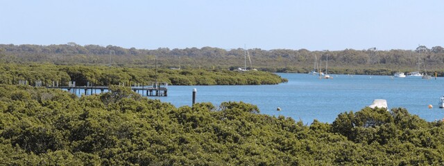
Situated within Victoria’s Western Port Bay, Casey’s coastline encompasses the communities of Warneet, Cannons Creek, Blind Bight, and Tooradin. The coast is important for the animals and ecosystems that live in this area, particularly the endangered species of shorebirds that reside in native mangroves, seagrass beds and saltmarshes. Not only this, but the coastline is also important for the economic vitality of the Casey community.
Reports have shown an increase in sea levels in Western Port Bay, causing hazards of land erosion and temporary flooding. These hazards continue to negatively impact environmental, economic and social factors of the community.
The framework is being funded through the Department of Transport and Planning’s Coastal Planning Grants program.
“A changing climate is expected to increase the frequency of extreme weather events leading to greater damage from storm surges and intense rainfall events. At the other end of the scale, there will be longer and more severe droughts and heatwaves reducing freshwater inflows via Rutherford Creek and other waterways,” the City of Casey wrote.
To have your say, and find more detailed information about the framework, visit casey.vic.gov.au/news/have-your-say-draft-casey-coastal-framework